One of the ways that the Stormwater Program accomplishes its mission to "Protect People and Property from Harmful Stormwater Runoff", is through REVIEWING development for compliance with City Stormwater standards.
City Stormwater Criteria and
Floodplain Management
The City of Fort Worth is a beautiful place to live, work and play thanks to the Trinity River and its floodplain. The floodplains and adjacent waters are important assets that form complex physical and biological systems. When floodplains are preserved in their natural state, they provide open space areas for parks, bike paths and wildlife conservation.
Floodplains also reduce the severity of floods by storing rising waters and runoff. The natural vegetation in the floodplain improves the water quality of the lakes and rivers of Fort Worth by slowing down stormwater runoff, which allows sediments and other impurities to settle out.
The City's stormwater infrastructure and natural floodplains are interconnected throughout the City to convey stormwater runoff. As public and private development occurs, the City reviews each project disturbing one or more acres of land to ensure that stormwater runoff is conveyed as safely as possible. City staff ensure that federal, state, and City design criteria and regulations are met to allow the City to continue to grow while protecting people and property from harmful stormwater runoff. The Development Services Department implements the City stormwater and floodplain criteria for development. Questions regarding a specific project should be directed to Stormwater Development Services at SDS@fortworthtexas.gov
Integrated Stormwater Management (iSWM)

The iSWM Program for Construction and Development is a cooperative initiative that assists municipalities and counties to achieve their goals of water quality protection, streambank protection and flood mitigation, while also helping communities meet their construction and post-construction obligations under state stormwater permits.
Development and redevelopment by their nature increase the amount of imperviousness in our surrounding environment. This increased imperviousness translates into loss of natural areas, more sources for pollution in runoff, and heightened flooding risks. Stormwater Drainage Study and Grading Permit reviews are how the City reviews each development project disturbing one or more acres of land. Those reviews ensure that each project follows the City's stormwater design criteria and does not create an adverse impact to flooding on other properties.
Grading Permit
Please be advised that there are review fees associated with project submittals. Contact the Stormwater Development Services department at SDS@fortworthtexas.gov for advice on a specific project or to schedule a Stormwater Pre-Development Conference. Additional information is also found in the City Development Criteria section.
Residential Grading

City Council adopted a Grading Ordinance on June 5, 2012, after a series of reviews with stakeholders. Major features include:
- Land alteration in excess of 1 acre (effective Oct. 15, 2015) or more will require an approved Integrated Stormwater Management (iSWM) Plan Grading Permit. Previously, this approval was required for new plats. A $50 administrative fee will be charged for processing the Grading Permit.
- Single family and building permits applicants will be required to provide lot grading patterns. Non-standard (other than HUD) patterns will be subject to review. No fee will be charged for this requirement.
Private Lot Drainage and Private Lot Grading
A drainage problem within your lot or water running from lot-to-lot is considered to be a civil matter and is not regulated by the City of Fort Worth. Contact an engineer or landscape professional to assist you in solving these matters.
Floodplain Management & Development
 Floodplain management is a community-based effort to reduce the risk of flooding, resulting in a more resilient community. The City outlines its goals and objectives in the Floodplain Management Plan(PDF, 17MB), which is updated every 5 years with support and input from a stakeholder group made up of internal and external stakeholders.
The Zoning Ordinance, Floodplain Provisions Ordinance and the International Building Codes have special provisions regulating construction and other developments within floodplains. Without these provisions, affordable flood insurance through the National Flood Insurance Program (NFIP) would not be available to property owners in the City of Fort Worth. Any development in the floodplain without a permit is illegal. Such activity can be reported to the Stormwater Management Division’s Customer Service at 817-392-6261.
All development within the City of Fort Worth requires local and state permits. Review and permit fees associated with development in the floodplain are listed below. Contact the Stormwater Development Services department. All development within the City of Fort Worth requires local and state permits. Review and permit fees associated with development in the floodplain are listed below. Contact the Stormwater Development Services department.
| Floodplain Development Permit (FDP) Fee Schedule |
| Permit/Review Type |
Amount |
Description and Examples |
| Flood Study Review (FSR) |
$2,000 |
Separate from Drainage Study and follows FEMA regulations |
| Dual Flood & Drainage Study (FDS) |
$2,000 plus $10 per acre |
Combination study. City approval required prior to submittal. |
| Basic FDP |
$500 |
Utility crossing, stormwater outfall, at-grade paving, fence (outside Floodway), shed, etc. |
| Fill FDP |
$2,000 |
Flood study was required due to cut/fill in the SFHA or Zone A study, CDC, sump in SFHA, LOMR-F, etc. |
| Single Family Lot FDP |
$1,500 |
New construction or Substantial Improvement of a single-family lot/home, typically requiring a post-construction Elevation Certificate. |
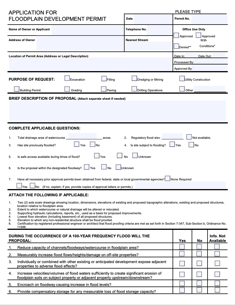
Download an Application for Floodplain Development Permit

Elevation Certificate
FEMA requires that a community's permit file must have an official record that shows new buildings and substantial improvements in all identified Special Flood Hazard Areas (SFHAs) are properly elevated. This elevation information is needed to show compliance with the floodplain management ordinance. The City uses the Elevation Certificate developed by FEMA to fulfill this requirement since it also can be used by the property owner to obtain flood insurance. This is also a requirement for the City's participation in the Community Rating System (CRS).
upon request by emailing floodplain@fortworthtexas.gov. If the City does not have an EC on file and one is needed for insurance or development purposes, you will need to hire a surveyor or engineer to complete it. Download a blank copy of FEMA's current Elevation Certificate(PDF, 4MB).
|
Community Rating System
The National Flood Insurance Program’s Community Rating System (CRS) is a voluntary incentive program that recognizes and encourages community floodplain management activities that exceed minimum requirements. The City of Fort Worth entered the CRS in 2012 as a Class 8 and improved to a Class 7 in 2023, resulting in a 15% discount on flood insurance premium costs for homes or businesses in the entire City. All property owners in the City are eligible to purchase flood insurance and receive the 15% discount, whether inside or outside of the FEMA regulatory floodplain. The three goals of the CRS are to reduce flood losses, facilitate accurate insurance ratings and to promote the awareness of flood insurance.
Floodplain Management is located at City Hall, 200 Texas St., and can be reached by email at floodplain@fortworthtexas.gov or by phone at 817-392-6261.
Additional guidance is available in the following FEMA resources:
|
Key Points for City Stormwater Development

- Land disturbing activity or platting of 1.0 acre or more or more OR land disturbing activity of less than 1.0 acre where the activity is part of a Common Land Plan Development will require an approved Grading Permit and Stormwater Drainage Study.
- When required, a detailed Stormwater Drainage Study (SWDS) must be accepted prior to the SUBMITTAL of a Concept Plan, Preliminary Plat, Final Plat, or the Infrastructure Plans to IPRC. Drainage Studies are submitted electronically through Accela
- Provide a Downstream Assessment through the Zone of Influence and provide an Adequate Outfall as defined in the CFW Stormwater Criteria Manual for Site Development and Construction.
- All drainage ditches and culverts carrying >10cfs require a HEC-RAS model for proper design.
- If infrastructure is not available to convey the fully developed flows from the development, the developer has the option to improve the downstream system and provide adequate outfall, or to detain storm water to pre-developed levels.
- If going through the IPRC process, a Stormwater Pre-con Checklist must be submitted and accepted during the IPRC review period. Items like a floodplain permit (FDP) or Stormwater Facility Maintenance Agreement (SWFMA) must be approved and/or executed prior to proceeding to construction.
- If detention is proposed, a storm water facilities maintenance agreement must be executed. See form CFW-8 for the SWFMA Checklist. No crossing utilities are allowed within detention pond areas.
- Maximum allowable driveway discharge is 3 cfs in a 5-year storm event
- Refer to Appendix F of the CFW Stormwater Criteria Manual for the CFW Storm Water Utility Fee Credit Policy
- Development along the TRWD Greenbelt Corridor may require a permit and coordination
- The building finished floor elevation and all electrical/mechanical equipment servicing the building must be 2 feet above the fully developed 100-yr Water Surface Elevation (WSE). When platting, establish the 100-year WSE to include a 10’ horizontal buffer and show on the plat in a dedicated floodplain easement.
- All public storm water must be contained in a public drainage easement designed to contain ultimate developed flows. No structures (walls, buildings, poles, etc.) are allowed within a public drainage easement without Development Service’s Stormwater approval
- Retaining walls are not allowed in drainage easements without Development Service’s Stormwater approval
- Maintain existing drainage patterns. No water should be conveyed from one watershed to another
- If the project affects existing CFW parkland please contact
PACS (PARD, 817-392-5743)
- Existing infrastructure plans are available. Please use http://fortworthtexas.gov/records/request/ to request them from the vault.
Email SDS at sds@fortworthtexas.gov to request any previously accepted SWDS’s
- Standard review time for all non CIP submittals is 10 business days.
Drainage Study review fee is $1,250 plus $10 per acre over one (1) acre.
Also view the Stormwater Design Criteria Manual(PDF, 10MB)

Find out more information visit Grading Permits
View All City project resource files.
For additional questions, please contact Stormwater Development Services
City Flood Risk Area
 The Floodplain Provisions Ordinance has proven to be very successful in reducing flood damages in or near the FEMA/City regulatory floodplains, but it does not address flood risks in areas outside of the FEMA regulatory floodplains. The City Flood Risk Area Initiative has been created to build upon the successes of the Floodplain Provisions Ordinance to reduce the flood risk in areas outside the FEMA/City regulatory floodplains by establishing consistent development guidelines managed with local resources. The three key components to reducing flood damages in City Flood Risk Areas (CFRA) are mapping the risk areas, communicating the risk to end users, and regulating how developments occur in risk-prone areas.
The Stormwater Criteria Manual will soon be updated to include a section that explains the difference between the different flood risk areas within the City and will outline the requirements for developing within a designated CFRA once it has been adopted by city council. The City Floodplain Provisions Ordinance and the criteria manual will specify the requirements and prohibitions that apply to a particular property. View the City ordinances.Specific questions or comments about the proposed CFRA development requirements can be directed to Stormwater Development Services (SDS@fortworthtexas.gov).
Key Points for FEMA Floodplain Development

The list below highlights key points for FEMA Floodplain Development. Complete drainage regulations can be found in the Stormwater Criteria Manual(PDF, 10MB) (see Key Points for City Stormwater Development and Floodplain Provisions Ordinance.
- Proposed development within the FEMA regulatory floodplain or floodplain easement (i.e. proposed grading, headwalls, fences, etc.) will require a Floodplain Development Permit (FDP), please submit your application package on-line in Accela.
- When required, a detailed flood study must be accepted prior to the SUBMITTAL of a Final Plat or the Infrastructure Plans to IPRC. Flood studies are also submitted through Accela.
- Proposed grading that would result in reclamation or alteration of the FEMA regulatory floodplain or is designated as Zone A floodplain will require the submittal of a pre-project flood study followed by a post-construction flood study and request for Letter of Map Revision (LOMR) from FEMA.
- Standard review time is 15 business days for Flood Studies or dual Drainage/Flood Studies and 10 business days for FDPs
- A Pre-Submittal meeting with Floodplain Management staff is required before submitting all flood studies. Contact SDS at SDS@fortworthtexas.gov to arrange the meeting. SDS staff can also be invited to the Pre-Submittal meeting upon request to discuss specific drainage issues.
- Any project proposing grading or structures within a floodway would need to result in a 0.00 foot rise in BFE or require a CLOMR approved by FEMA before an FDP can be issued. Any project proposing grading in the floodplain fringe resulting a more than 1.0 foot rise in BFE would also require a CLOMR.
- Projects located within the Corridor Development Certificate (CDC) regulatory zone will require approval of the Final Action Form prior to FDP Issuance. The latest CDC Manual, application, and the new consolidated FEMA/CDC model can be found at the following link: http://www.trinityrivercdc.com/.
- Projects located within a FEMA sump area will need to maintain valley storage below the Base Flood Elevation (BFE). Please contact Floodplain staff to verify the correct BFE and discuss any other development requirements for this area, such as flood vents and floodproofing.
- The building finished floor elevation and all electrical/mechanical equipment servicing the building must be 2 feet above the fully developed 100-yr Water Surface Elevation (WSE). When platting, establish the 100-year WSE to include a 10’ horizontal buffer and show on the plat in a dedicated floodplain easement.
Substantial Improvements Requirements
Substantial Improvement – The National Flood Insurance Program (NFIP) requires that if the cost of any reconstruction, rehabilitation, addition, or other improvement to a structure exceeds 50 percent of the market value of the structure before the start of the construction, the improvements must conform to or meet the same construction requirements as a new building and satisfy minimum finish floor requirements specified in the Floodplain Provisions Ordinance.
Substantial Damage – Substantial damage means damage of any origin sustained by a building or structure when the cost of restoring the building to its pre-damaged condition would equal or exceed 50 percent of the market value of the building before the damage occurred. Substantial damage is determined regardless of the actual repair work performed.
The City of Fort Worth requires by ordinance that any substantial improvement or substantial damage improvement must have a building permit. Building permits can be obtained from the Development Services Department located at City Hall or by calling 817-392-2222.
|
Development Review Contacts
For questions about any development anywhere within the City of Fort Worth, contact the Development Services Department at 817-392-2222 or visit Development Services.
For questions or concerns about development specifically in a floodplain within the City of Fort Worth, contact the Stormwater Development Services department at SDS@fortworthtexas.gov.
|
Stormwater Download Viewer - Self-Service Data Access & Permits Website
The City of Fort Worth’s Stormwater Management Division has launched a new self-service website. Property owners, developers and engineers can now download Drainage Studies, City Stormwater Studies, Flood Studies, Floodplain Development Permits, and Elevation Certificates.
Visit Stormwater Download Viewer
The big picture: The website will allow the public to review and download City and FEMA data that is relevant to their project needs immediately, without submitting a Public Information Request (PIR). The mapping feature provides the users the ability to search available data by address or cross streets. As more data becomes available, the website will continue to be updated regularly. The website is not intended to replace Pre-Development Conferences and Pre-Submittal meetings.
